Wednesday, October 14, 2009

Mussoorie - Uttaranjal


MUSSOORIE    -   UTTARANJAL

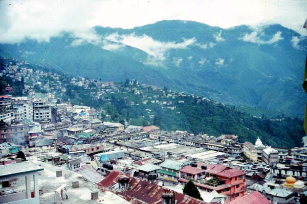
Popularly known as the Queen of Hills, this charming hill station, 34 kms from Dehradun is situated at an altitude of 2003 mts in the Garhwal hills. above sea-level. Mussoorie is one the beautiful hill stations in India and the most frequently visited. It provides excellent respite to people who want relief from the hot sultry conditions of the plains, especially since it is close enough to the capital to make just weekend trip. Also, major Hindu pilgrimage sites like Kedarnath, Badrinath, Gangotri, Yamunotri, Haridwar, Rishikesh are not far from this place.


Best Season:
April to June and again during September to November

Route Map:
View Larger Map


Getting There:
Air :
The nearest Airport to Mussoorie is 60-kms away from the place. The airport is called Jollygrant Airport but there are no regular flights to this place.

Rail:
Mussoorie does not have a direct rail link. Dehradun Railway station serves for Mussoorie too. This station is linked which Superfast trains to other major cities in country.

Road:
From Dehradun one can hire a taxi or take a bus to Mussoorie. The queen of hill stations is well connected with roads with other major cities. There are regular bus services from various metros and other tourist destinations in Uttaranchal as well as from out side the state. Bus services are provided by State transports. There are conducted tours to Mussoorie too.


Sightseeing in Mussoorie:


Kempty Fall
15 kms from Mussoorie on the
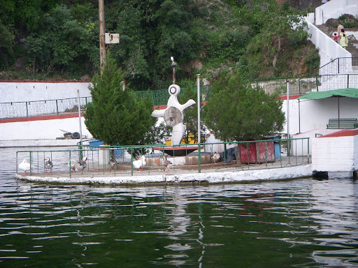
 Yamunotri Road having an altitude of 4500 ft. It has the distinction of being the biggest and prettiest waterfall located in a beautiful valley and is surrounded by high mountains. Bath at the foot of the falls is refresshing and enjoyabled for children and adults alike.


MussoorieLake
 A newly developed picnic spot, situated on Mussoorie- Dehradun road and is about 6 kms from Mussoorie. It is a delightful spot. Pedal boats are availble. It commands an enchanting view of
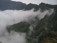
 Doon Valley and nearby villages.


Gun Hill
One can enjoy a thrilling ropeway ride to Gun Hill, the second highest peak of Mussoorie(2122 mts). The peak offers a panoramic view of the Himalayan ranges.

Camel’s Back Road:

It starts from Kulri Bazar near Rink Hall and ends at Library Bazar covering a total distance of about 3 kms. The main charm of this froad is horse riding and wlking. Sunset view of the Himalayas is superb. Camel's Rock with a life like resemblace can be seen from the spot near Mussoorie Public school

Surkanda Devi

Situated at an elevation of 3030 mts above sea level near village Kaddukhal the temple of Surkanda Devi is 33 kms from Kaddukhal and one has to trek about 2 kms. The temple of Surkanda Devi is situated on the top of the mountain and is of great religious significance. A fair is held every year on “Ganga Dussehra” during May-June in which thousands of people participate.

Van Chetna Kendra:
At a distance of about 2 kms on Tehri bye pass road, this place is developed as a picnic spot and has a park surrounded with pine forest and flowering shrubs, and is approachable by foot or taxi/car. The main attraction is the wildilife of the park like Ghurar, Kanankar, Himalayan Peacock, Monal etc.


Municipal Garden


The garden with its artificially created lake is a perfect picnic spot.

Lal Tibba:
This place is highest point in Musoorie. Lal Tibba is located in Landour area which is the oldest inhabited place in Mussorie.


Jwalaji Temple (Benog Hill) 9 kms to the west of Mussoorie and at an altitude of 2104 mtrs. Is the Jwalaji Temple. It is situated on the top of the Benog Hill and has an idol of Mata Durga in it. The temple is surrounded by thick forests and offers a panoramic view of the Himalayan peaks, Doon valley and Yamuna valley.


Nearby Attractions from Mussoorie:

Nagtibba


34 kms from Mussoorie one reaches Thatyur. 7 Kms further is devalsari and a  14 kms further trek to Nagtibba is an ideal spot for trekking.

Sahastra Dhara:
Located 14 km from Dehradun is the famous picnic spot called as the Sahastra Dhara. Noted for their astounding beauty the medicinal sulphur waterfalls are a great attraction.


Dehradun:
Located 29 Kms. from Mussoorie, Dehradun is a must visit place. 


Haridwar-- gateway to the four pilgrimages in the Uttrakhand region, is located on the foot hills of Shivaliks.


Rishikesh:
Rishikesh is just 24 Kms from Haridwar. Located in the laps of lower Himalayas, this place is considered to be the access point of three other pilgrim places of Badrinath - Kedarnath, Gangotri and Yamunotri the four great places which combine to make Chardham .


Dhanolti


24 Kms from Mussoorie, Dhanolti provides a breath-taking view of the valleys and the Himalayan peaks. The long wooded slopes, lazy outings, cool caressing breeze, warm and hospitable inhabitants, lovely weather and fabulous view of of snow covered mountains makes it an ideal retreat for a relaxed holiday


Food and Stay:


Other hill stations in uttaranjal
» Chamba
» Kanatal
» Kausani
» Almora
» Nainital
» Mukteshwar
» Pithoragarh
» Lansdowne
» Ranikhet


Adventure in Mussoorie


Munnar - Breathtakingly beautiful Hill


BREATHTAKINGLY BEAUTIFUL MUNNAR

Located on the Western Ghats, Munnar is a charming hill station. It promises travelers a complete holiday experience amidst lakes, reservoirs, forests and tea estates. Sprawling tea plantations, picture book towns, winding lanes and holiday facilities make this a popular resort town.
This hill station is133Kms from Cochin, with an altitude ranging from 1600 to 1800 meters above sea level. Munnar boasts the highest peak in south India 'Anamundi' 2695 meters high. Munnar was the favourite summer resort of European settlers for centuries. The name 'Munnar' means 'Three Rivers' and they are actually three mountain stream, Muthirapuzha, Nallathanni and Kundala, confluence at the heart of the town, meeting all the water requirements of the settlers and visitors.


About Munnar:

Languages : English and Malyalam
Best Season : October to March
STD code : 0486
Weather : pleasant weather
Summer :April to June - mild
Winter : November to February – cool

Route Map:
View Larger Map


How to Reach:

By Air : The nearest airport to Munnar is at Kochi, 130 km away, which can be accessed by the local modes of road transport available from Munnar town.
By Rail : The nearest railhead from Munnar is at Kochi. The railway station can also be accessed from the town by the local modes of transport.
By Road : Munnar is accessible by road from most of the towns in Kerala. It can also be reached from Madurai (six hours) and Coimbatore (six hours), which are located in the state of Tamil Nadu

Munnar is 192 Kms from Alappuzuha
224 Km from Cochin
117 Km from Thekkady

Places of Interest:
Echo Point , 15 km from Munnar, this scenic place gets its name from the natural echo phenomenon here. Echo Point is on the way to Top Station from Munnar


Top Station
Situated at an altitude of 2,200 m, Top Station offers wonderful views of the valley down below and panoramic landscape. The hilltop is situated at a distance of around 41 km north from Munnar town on the Tamil Nadu-Kerala border. According to a local belief, the place derived its name from Middle Station and Lower Station, both lying down the valley, which were once connected to this place via a ropeway.

Pothamedu is located 6 km from Munnar and offers an excellent view of the tea, coffee and cardamom plantations in Munnar. The rolling hills, the lush mountain and the breathtaking scenery here is ideal for trekking and long mountain walks.

Anaimudi: It is the highest peak (2695m) in South India, can be viewed from Munnar.

The Eravikulam National Park: is a must for tourists wishing to experience a bit of wilderness while on Kerala travel. The foundation of the sanctuary was laid for the preservation of Niligiri tahr, one of the endangered species of the planet.. It spreads over 97 sq km and was declared as National Park in the year 1978.The nearest airport is 135 km away at Kochi and the nearest railway station is at alluva, 115 km . The park is 17 Kms from Munnar

Devikulam (7 km from Munnar)
This idyllic hill station with its velvet lawns, exotic flora and fauna and the cool mountain air is a rare experience. The Sita Devi Lake with its mineral waters and picturesque surroundings is a good picnic spot. The lake is also ideal for trout fishing.

MARAYOOR (40 Km from Munnar)- This is the only place in Kerala that has a natural growth of sandalwood trees. The Sandalwood factory of the forest department, the caves (muniyaras) with murals and relics from the New Stone Age civilization and the children’s park spread across a hectare of land under the canopy of a single Banyan tree are of great interest to tourists. Thoovanam water falls and Rajiv Gandhi National park are also near by.

Nyayamakad is 10 km from Munnar is located between Munnar and Rajamala, Nyayamakad is a land of breathtaking waterfalls. The waters cascade down a hill from a height of about 1600 metres. The enchanting surroundings makes an excellent picnic spot and trekking point.

The Chinnar Wild life Sanctuary: is 10km from Marayoor and 52km from Munnar. This sanctuary is the home of elephants, leopards and bears.

Pallivasal is 8 km from Munnar is the venue of the first Hydro Electric Project in Kerala and a place of immense scenic beauty.


Chithirapuram, 10 km from Munnar is known for sleepy little cottages, bungalows, old playgrounds and courts, Chithirapuram still exudes an old world charm. Home of the Pallyvasal Hydel Power Project, this hill town is also famous for its picturesque tea plantations.


Cheeyappara
Located between Neriamangalam and Adimali on the Kochi-Madurai Highway, Cheeyappara and Valara waterfalls are a treat to the eyes. The fall cascades down in seven steps making it unique

The Christ Church:
The British built the Christ Church in 1910 AD. Built of stone, the church is known for its stained glass windows. There are several brass plaques in the church placed in the memory of the tea planters

Attukal is 9 km from Munnar is a panorama of waterfalls and rolling hills, Attukal, located between Munnar and Pallivasal, is a feast for the eyes. The place is also ideal for long treks


Where to Eat:
Munnar is not only famous for its mountains, waterfalls and plantations but even mouthwatering cuisines which will surely pamper your taste buds. From the spicy and fried delicacies to the delicious South Indian cuisines there are a number of restaurants in Munnar.
The Greens and the Blues
Saravana Restaurant
Rapsy Restaurant
Silver Spoon
Cloud 9
Poopada
Hotel Gurus

Apart from these there are a number of restaurants in Munnar which serves vegetarian and non vegetarian food.


Similar places of Interest:
» Almora
 » Coorg
 
» Kalimpong
 
» Lonavala
 
» Munnar
 » Pachmarhi
 
» Srinagar


Sikkim and Darjeeling


DARJEELING  Queen of Eastern Himalayas
Darjeeling is known for its scenic natural beauty, snow clad Mountain View, green hill forest and sweet people. This marvelous hill station provides you a tremendous relief form stress, which forced you to go Darjeeling.One can enjoy seeing snow covered Kanchenjunga and Everest Peaks from Darjeeling.The tourist flow to this place has been increasing day by day.
Darjeeling has some of the lovely tea plantations (estates) in the country. Darjeeling is a place where one feels as if being in the lap of mother nature. Darjeeling is also a trekkers paradise and the Gorkha hill council has provided ample trekking facilities for the adventure loving people.


Location:
Situated in the Shivalik Hills, on the lower range of the Himalayas, . It is situated at the height of 2134 meter from the sea level.
Temperature 
Summer : Max  14.89 °C, Min  8.59 °C.
Winter : Max  6.11 °C, Min 1.05 °C.

Best Time to Visit
The best time to visit Darjeeling is during the months of April to June and September to December. During this time, the weather conditions are at their best, for roaming around the place as well as for indulging in various adventure sports.

Route Map:
View Larger Map

Getting There:
By Air
Bagdogra is the nearest Airport with flights from Kolkata, Delhi and other major destination within India. Bagdogra Airport is a mere 2 hour drive from Darjeeling or from Kalimpong.

By Train
N.J.P. and Siliguri are two nearest Railway Stations. Trains for all the important cities of India can be availed from these stations. Tickets for Air and rail can be booked in advance from the out agencies in Darjeeling, Kalimpong and Kurseong.

By Road
Darjeeling is well connected by all weather roads to all the parts of the state and the state of Sikkim.


Sight Seeing places In Darjeeling:

Chowrasta:

This one of the important shopping places in Darjeeling . Here the Nehru Road and the Mall Road Intersect each other. The snow capped peaks of Kanchenjunga are visible from this place. Near Chowrasta are several Hindu and Buddhists temples. This place is over flowing with foreign tourists. You can also enjoy a pony ride form this place.

Kanchenjunga View:

From Darjeeling one can have the best, uninterrupted view of the worlds third highest peak. Bhan Bhakta Sarani provides one of the enthralling views of these snow capped peaks. The Chowrasta also gives you a good sight to the Kanchenjunga peak

Tiger Hill:
Tiger hill is a highest peak in the town, with a 2590 meter height. From this height you can see the highest peak of the world Mount Everest and Kanchenjunga, with a majestic view of eastern Himalayas. From this height you can enjoy the miracle, that how sun merges in the snow covered mountains.

Batasia Loop:

This railway loop is an interesting example of engineering. At this loop the toy train takes a very unique turn. This loop is just five kilometer from the main town of Darjeeling. This place also has a very good market where you can buy the purses, bags and other decorative items made by the local women at very reasonable price.


Dhoom Gompa - About 8 kms from Darjeeling is the Dhoom Gompa. Here a very beautiful statue of the Maitrayie Buddha ( prospective Buddha) is established. The Monastery has also preserved some of the rare handwritten Buddhist manuscripts.


Ghoom:

Two kilometers from Darjeeling is the town of Ghoom which is the highest railway station in the world. It also has a monastery.


Bhutia Busty Gompa
With the back drop of the Kanchenjunga range stands a monastery called the Bhutia Busty Gompa. This monastery was shifted from the observatory hills to the present place. The Gompa is a branch of the Nyingmapa sect's Phodang Monastery in Sikkim. The monastery is not far from the chowrasta and is very tastefully decorated. It also has a library which has a copy of the Tibetan Book of the Dead.


Toy Train:
The toy train coming from Siliguri is some thing which is liked by the elders and the children equally. The real fun in coming to Darjeeling is on the toy train. It takes six to seven hours to cover a distance of 82 kms and the slow speed gives you enough time to watch and appreciate the beauty which nature has provided it. This train passes through the Forests, waterfalls, over deepvalleys and through the mountains and tunnels


Passenger Ropeway - Another tourist attraction in Darjeeling has been the ropeway. This was the first ropeway in India. It connects the North point (7000 ft) to the Singla Bazaar (800 ft). The rope covers a distance of 8 kms in 45 minutes. The seats in the rope way is limited and it is better to get the tickets in advance. The ropeway is exciting and unique for any one visiting Darjeeling.


Senchal Lake
A
scenic place near the tiger hills. This place has popularly come up as a picnic spot among the tourists. The lake supplies drinking water to the town of Darjeeling.


Nearby Attractions from Darjeeling:


Mirik
Mirik is 52 kms from Siliguri and 55 kms from the nearest Airfield of Bagdogra. Mirik is being developed as a new hill station in the mountains. Mirik is surrounded by tea estates, orange orchards and cardamom plantations. It has all the facilities to fulfill the needs of a tourist.

Kalimpong : Kalimpong is within Darjeeling province and is a sub-division of Darjeeling. It is a small but bustling town in the Himalaya foothills of West Bengal- Kalimpong is at an altitude of 1250 meters. This bazaar town was originally a part of Bhutan but later it was taken over by the British and finally it settled down with West Bengal


Kurseong:
Kurseong is mid-way between Siliguri and Darjeeling. The way from Darjeeling to Kurseong is generally open through out the year. So, the toy train is not coming to Siliguri then one can come up to Kurseong. This place is equally beautiful and is full of natural splendour.


Food & Accommodation:


Other Holidays Packages